India Reports

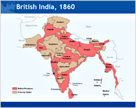
PPT Map of British Raj Rule in India pre 1947 - editable in PowerPoint

Title
Date
No of pages

PowerPoint Map Indicating British Rule in the Indian Subcontinent

APR 2009
1 slide

You can do a lot of things with our PowerPoint Editable Maps.

This PowerPoint presentation includes the following information contained on a single slide:

British rule in 1860
British Provinces
Princely States

The British Raj or rule lasted in India from 1858 to 1947. This particular PowerPoint map indicates the state of the Indian Subcontinent in 1860. Queen Victoria who ruled from 1858 to 1901 was the reigning monarch at this time. Exactly three years before this map period, The Great Uprising of 1857 swept throughout the subcontinent. This presentation will serve as a great teaching tool. Use it as a standalone map, for teaching a class or to aid a quiz presentation.

The Major Provinces:

Burma
Bengal
Madras
Bombay
United Provinces
Central Provinces
Punjab
Assam

Also included for accuracy are, The Andaman & Nicobar Islands and Lakshadweep, with the Bay of Bengal and Arabian Sea being indicated.

Simply "ungroup" the image and then you can use this useful tool to indicate locations, shopping malls, places of tourist interest (if you are a travel operator).
You can customize this map along with other data you wish to present. For example if you are presenting the population growth of certain states in India, you may highlight only those states.

You can pinpoint the location of small towns or villages that are not available on existing maps and can even pull out and separate the states you require to give even greater emphasis to your presentations.


Editable PPT Map of the British Raj in India

Product sold as MS PowerPoint 2003 version.

Buy Now
US$7.99

Add to Cart 


British India Map

Inside view of British India Map

How to edit maps

24point0 ad

Description of our unique Editable Maps of India

India PowerPoint Maps


Watch the video on editing maps

back to top


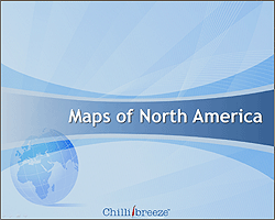
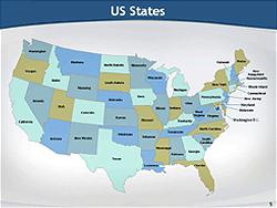
Also available: Editable maps of North America: USA, Canada and Mexico

Maps of North America  inner slide view

Buy Now!


Find more reports and presentations with a focus on India


Food & Retail - Visual Merchandising, Pharma, Discount, Malls, Single Brand Stores, Wine, Cheese, Retail Scene

Travel & Tourism - NE Travel Guide, Delhi, Myths about India, Retiring in India, Jaipur Guide, Spirit of Dasara, Guide to North Indian Cuisine

Expat & NRI Resources - Investment and Tax FAQs for NRIs , City Guides, Holidays in India, Living in India, The Young NRI and Life in India

Emerging Services and Industries - Real Estate, Medical Tourism, BioTechnology, eCommerce Industry in India, eLearning industry in India

Trends, Statistics & Developmental - Electricity in India, Inflation Survival Guide for India, Pre-Hire Assessment and Testing in India, Indian Youth Readership Trends

Outsourcing - Legal, Accounting, KPOs, SMEs, HR, Top 10s

Editable Powerpoint Maps - India, North America, Rivers of India, Wine Regions, Demographic Maps, Tea Producing Areas, Monsoon Map of India,

Book Summaries - Go Kiss the World , It Happened in India, In Spite of the Gods, India Express, India: From Midnight to the Millennium