This PowerPoint presentation includes the following information contained on a single slide:
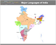
Language distribution according to states
The official language of the Republic of India is Hindi. English enjoys associate status but is the most important language for national, political, and commercial communication. Presently the official number of languages for India is 418 and out of this 11 have become extinct. Some languages, which are given the status of minority languages, as they are not widely spoken are: Mahl, language of Minicoy island of Lakshdweep, Puducherry, language of Pondicherry and Portuguese language spoken by the people of Goa, Daman and Diu, are some examples.
This presentation will serve as a great teaching tool. Use it as a standalone map, for a teaching class or to aid a quiz presentation.
Official Languages of the State Governments of India
1. Assamese — official language of Assam
2. Bengali — official language of Tripura and West Bengal
3. Bodo — official language of Assam
4. Dogri — official language of Jammu and Kashmir
5. Garo — official language of Meghalaya
6. Gujarati — official language of Dadra and Nagar Haveli, Daman and Diu and Gujarat
7. Kannada — official language of Karnataka
8. Kashmiri — official language of Jammu and Kashmir
9. Khasi — official language of Meghalaya
10. Kokborok — official language of Tripura
11. Konkani — official language of Goa
12. Malayalam — official language of Kerala, Lakshadweep, Pondicherry
13. Maithili — official language of Bihar
14. Manipuri or Meithei — official language of Manipur
15. Marathi — official language of Maharashtra
16. Mizo - official language of Mizoram
17. Nepali — official language of Sikkim
18. Oriya — official language of Orissa
19. Punjabi — official language of Punjab and Chandigarh, second official language of Delhi and Haryana
20. Sanskrit — language of Hinduism, required teaching in many schools
21. Santali — language of the Santhal tribals of the Chota Nagpur Plateau (comprising the states of Jharkhand, Bihar, Orissa and Chattisgarh)
22. Sindhi — language of the Sindhi community
23. Tamil — official language of Tamil Nadu and Pondicherry
24. Telugu — official language of Andhra Pradesh
25. Urdu — official language of Jammu and Kashmir, Andhra Pradesh, Delhi and Uttar Pradesh
Also included for accuracy are, The Andaman & Nicobar Islands and Lakshadweep, with the Bay of Bengal and Arabian Sea being indicated.
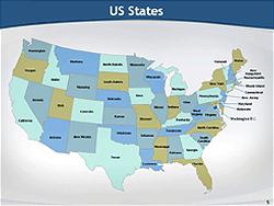
Simply "ungroup" the image and then you can use this useful tool to indicate locations, shopping malls, places of tourist interest (if you are a travel operator).
You can customize this map along with other data you wish to present. For example if you are presenting the population growth of certain states in India, you may highlight only those states.
You can pinpoint the location of small towns or villages that are not available on existing maps and can even pull out and separate the states you require to give even greater emphasis to your presentations.
|
|